August 9th -18th, 2008
Day One
Arrived in Salt Lake City with memories of the previous trip earlier in the year which brought Roxy home. Rented a Jeep Patriot and we were on our way after a stop off highway 6 to pick up food supplies for the week and beer. Now we were ready!
Highway 62 to Moab has a few surprising areas but all in all, it was the solitude we were looking for. We came through a heavy downpour that included hail the sized of golf balls that concern me and damage to jeep. The lightning in the western horizon was powerful. What a beautiful place!
 Passing green River was surprisingly small as to this was a spot that General Powell left for his journey (Add history)
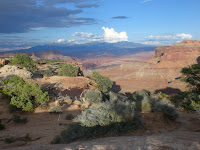
Went in to Moab to get fuel and drove back to Canyonlands for the night. Wow! Continued to the Syncline trail where we made camp about 2 miles in as the sun was dipping below the horizon. It grabbed our beer and climbed the steep face to enjoy the coming night this lightning, and good conversation. The night was remarkable.
Day Two
A walk at sunrise from camp about 7 a.m., made breakfast a continued the 9 mile hike around the trail and the upheaval rock. How the landscape changed at every few degrees based on shading and potential water sources. The north side of the loop was an oasis that contains green trees and lush grasses. Such the contrast to the backdrop. We arrived at the car near noon and drove to Moab for last-minute supplies.
 After Moab we drove to the Arches national Park that was forewarned at the Gearhead Shop that it was very crowded and little chance for a camping spot. We went away and found that he was correct however the good thing about tour straps is that only the first few miles of any trail is busy due to the actual work involved. When we started our hike at 3 p.m., we never anticipated we would hit every arch that day that is on the map. Included were Landscape, Double O, Private, Pine Tree, Tunnel, Skyline, Sand Dune, Broken, and Delicate Arch.
The final arch weeks all was the delicate arch because this was a moment I will never forget we hopped the 1.5 mile trail as the sun was quickly ascending the rock face that leads to the arch. I have seen pictures of this before but never the surroundings. Wow! How God created this place is truly a miracle because not only is the arch a single face area cleared by the fast win an included is an amphitheater setting that could not have been designed by anyone but God himself. The beauty of this arch is to see it as the sun is reflecting the colors and weak and failed to get there by then but that was all right because to crowds were leaving and the place was mystical. I place this area in this same as the
  Stonehenge because of its powers. Hard to explain but will is a defining moment for the rest of my life. We raced down, helped a couple from Seattle lost in the dark, snap some pictures of ancient petroglyphs.
We went to the Moab for a about 10:30 p.m. at another beer and drove in the night to the next adventure, the needles in Canyonlands national Park. Why the way I write this at night under the stars awaiting the coming meteor shower sleeping next to a cactus in a bivy.
Day Three
After breakfast decided to spend the day I hiking to Druid arch and the south end of the needles. Left-hand and started down the lush brush green landscape surrounding by the needles backdrop. The first and second leg was 2.3 miles from camp that dropped into elephant Canyon. From there it was 2 miles through the canyon floor to Druid arch. Along the way we encountered numerous small waterholes in the middle of 100° heat that proved a lifesaver on the way back. We ascended the final push to the arch and found it to be the most massive arch we have seen in the previous days. After a quick break, we continued back to our hole and jumped in for a clannish. This refreshed us so much that we push past are turned off and completed the second loop of the day. The total was 12 miles in the hundred degree heat.
After dinner of rice and beans, we took in night stroll another 2 miles to complete a day of 14 miles. We slept under the stars awaiting them meteor shower but I waited for the bright moon to lower, fell asleep to way can find no shower. What a night that I slept so well. Life is great.
Day Four
Got a remarkable sleep last night under the stars and only turned a couple of times. Made breakfast and prepared our hike that would take us another nine plus miles today we started her figure 8 loop on the middle section going west toward doubles kitchen. The north end of the loop is another lush oasis surrounded by a majestic backdrop of autumn colors sandstone rocks making a contrast pleasing to the eye. Continuing on the next 2.3 section, we traverse the high point near the needles that provided a Birdseye feel to the north that included the island in the sky, Moab, and the mountain ranges that included mountain peak at 12,721 feet.
We found our first rattlesnake of the trip that nearly got me off the side of the trail. Once we got back to the original starting point and a short break, we continued on to the original crossroads of 1.3 miles and took a left instead of a right toward the Jeep Trail. Crossing this area brought us to deep covered canyon or hundreds of cairns or more demonstrating the magic of this spot. From there a single wall crack in the canyon no more than 2 1/2 feet wide continued for quarter mile or so to a steep stairway leading near my favorite, or one of my favorite, spots in the world that gave a full view of the grassy push prairie that a comp is nearly 8 mi.² the needles and the surrounding area with its clear blue sky that held in the distant the green River and Colorado River canyons truly another magical point. The hike back to camp was around to a half miles which we could see to the sandstone needles in the middle of the vast prairie. Once back we had lunch broke camp and ascended the 3.1 miles in the searing heat of the afternoon. In the desert conditions, the 1 1/2 hour trip with Jim Morrison and the doors was deeply spiritual.
We took a bath in the camps say and started our way toward Lake Powell. We passed Monument Valley nearing sundown and captured some remarkable pictures. Once we arrived at night and Page, Arizona we continued to a secluded beach and can't they be style 2 feet from Lake Powell. Another great day.

Day Five
Woke up with much sand in my sleeping bag. As usual we fired up the butane stove and made coffee with oatmeal for breakfast. Beautiful morning as we were surprised the solitude of the area with only a few others to her right at the primitive beach. Knowing that our stench was getting worse even though we took a bath in the sink yesterday, all hot shower sounded pretty good. We went into the Marina north of page or reborn with hot water.
Now was the time to look for a boat to rent so we can explore up River for the next two days. We found the boat rental shop and picked a two person open kayak for the expedition. Lake Powell was beautiful but all others also felt the same way with hundreds of boats, jet skis, and houseboats on the water. After paddling to the far side of the bay we found that the drop in water elevation had a profound effect on the area. The map from the national Park resembled little of what we actually found because the water cut off all access to the north part of the lake except for a small inlet that every boat on the lake was going through. Knowing this journey included adventure, flexibility, and keeping it on the move, we decided it was best to turn in the boat and head toward Grand Canyon to give us an extra day at Zion. We left a crowd and headed on Highway 89 South of page. We followed the 89A turn off and passed the Vermillion Cliffs before heading up the final plateau to the north rim.
We went to get our permit, and the warden that issues the backcountry permits gave us the riot act on our plans to hike the north rim to Bright Angel Camp ground is only 14 miles one way. She told us that this was a bad idea and the conditions at the camp were hostile at this time of the year. Bottom line is we have hiked for nearly 50 miles in areas that did not offer water and held temperatures just as hot as this. The trail to Bright Angel campground maintain water sources proximately every 2 miles until it Matt out with Bright Angel River that flowed the remaining way to the Colorado River next the trail. Anyway, what she did know is we were secretly thinking of hiking to the South rim in our subconscious minds, but this would give her a heart attack. We got our permit for the next day, and went back to camp at the national forests directly north of the park.
Day Six
Woke up and as usual prepared breakfast, quickly broke camp, and left for the north rim trailhead. At this point our intentions or hike to the Colorado River, spend the night at hike back out the next day. We hit the trail around 9 a.m. and down climbing tool we thought was cottonwood camp around 9 a.m.. Taking we just went 6.9 miles in two hours we got a little cocky. There was an open camping area on this flat that included a cabin, old basketball hoop, or shoe area, and will we soon found to be a helicopter landing pad. Spending little time we left the small group of tense and started off again. As we turned a corner a helicopter came up through the canyon and landed on the exact spot where we just came. About a half mile later, we should role than him for a little the cottonwood camp to realize the prior stop was roaring Springs that did not include a sign. There are two things that threw us off high above we had passed a sign that led to roaring sprays that in turn had to waste down. Second the campers confuse us because we knew there was no camping at the stop. We later realized that the turnoff far above was to the waterfalls itself leading to Roaring Springs. Anyhow we struggled off the mistake and continued the remaining 6.9 miles to Bright Angel Camp.
At this point it was only 9:30 a.m. at the heat intensified as we went into the deeper canyon caused by it's oven environment with dark, boxed in walls. As mentioned before, the Bright Angel River proved vital on numerous occasions with a deep soak of our heads and bodies. In this intense heat which must have caused this delirious suggestion, but it was at this point I suggested we up the stakes and complete a rim to rim to rim with a midnight push for the South ram mountaineering style. Seconds later the deal was complete and new quest was set.
Climbing the Grand Canyon is hard enough but the added summer heat makes it twice is difficult. Our plan was to beat the heat and get up around midnight, cook breakfast, and leave for the South ram at 1 a.m. getting asked to the summit at 5:30 a.m., perfect time for a sunrise. The South rim is 6.9 miles from Bright Angel campground with an elevation gain of an approximately 4200 feet. As we strolled into the camp around in we knew we had a long day ahead requiring 28 miles and 13,000 feet elevation gain an extreme heat the last 14 miles. We enjoyed the camp with the river running through it, explored the Colorado River, and went to bed at 930 with the alarm set for midnight. For some reason I had trouble getting to sleep and didn't fall into sleep I would guess until 9:30 p.m.
Day Seven
The alarm sounded at midnight and we woke up to a crystal clear night. After breakfast we left camp in our headlamps at 1:05 a.m... Like any mountaineering trip traveling at night gives one another sense to traveling in the day. With only the beam of our headlamps or direction, steps are calculated with the hidden darkness below. We continue to ascend the South rim and nearly reached the top when we heard something in the distant that turn out to be a pair of deer heading straight down the face. Also we were met at the finals which backed by a team of mules led by a driver taking supplies to the camp were we had came. This historical mode of transportation in depths of the night felt as if I had to step back in time. We turn off our headlamps not to bother the meals as they passed, and the mule driver clearly looked in the moonlight from another era. It was still deep in the night as we arrived at the rim at 4:30 a.m. with a chill in the air flowing to the trees. We attempted to take a small nap on a nearby picnic table to wait for the morning sun, but this proved difficult because we were out of in the night, in the cold, without anything to cover us.
A point to make here is that modern conveniences have helped the world see the treasures such as the Grand Canyon; however this also removes the sense of solitude from these places. And I know after a sending the Grand Canyon at night only passed by a team of mules delivering supplies to the Phantom Ranch that we did have a treasure tour sells at that moment in time. I know that the time was vital, but nonetheless, this night the Grand Canyon was are his alone.
We rested at the South rim for 20 minutes and decided it was best to keep moving instead of sitting in the dark morning chill. We left the rim at 5:15 a.m., with a few groups below that just got off the bus why we rested about. With this guy slowly illuminating with the coming morning, the views we did not see on the approach opens slowly with each step we talk. There is no question why the South rim is more popular with its instant views. including its shorter approach, as compared to the north side (Add South Rim Descriptions).
We arrived back at camp, nearing 8:30 a.m. and decided to take a nap on the opposite side of our camp across Bright Angel River before heading up the North rim. This however proved useless because the bugs and constant interruptions from the other campers. We decided to keep moving and cleared camp and set off for the final leg or second half of the 14 miles in the searing heat up from 2300 feet to 8600 feet. This was a known the most trying of the day are coming through the box canyon. The previous day, we knew the win and River would be in our favor, but now the route was reversed and the climb would be uphill to cottonwood camp 7 miles away. We arrived there nearing 12:45 p.m. and took a break until 1:15 p.m. was vital for our success to the car. From there, we came to our designated dinner spot of roaring springs at 2 p.m. We had the usual rice and beans and started off at 3 p.m. for the final and most difficult part of the journey. We had been on the move since 1 a.m. and the heat extract energy from your body much different than traveling in colder conditions. The final 4.7 miles up, proved to be a mental endurance challenge, but like all other clients. We push through and made it back at 5:30 p.m. to the car. We jumped in the Jeep, took much needed showers at the camp grounds, and started the drive to Zion national Park and our last stop of the journey. The distant western horizon, as we cross southern Utah included a magnificent lightning storm that would prove just south of our destination.
Day Eight
We ended up at the DNR camp 10 miles south of the Zion park entrance. We drove into the park. at first light and got inline for our backcountry pass. Talking with the gal at the counter, she suggested we hike the West rim to a series of campsites overlooking the sandstone ranges that make up much of the park giving us the solitude we were looking for. We paid our 10 box and headed to the trailhead via the bus system in Zion national Park. One thing that I liked about Zion is the efficiency of the park. It was remarkably beautiful, with a design of all buildings that perfectly fit the surrounding area. You could not drive up the only road that lead deep into the park, but they offered a bus service for all. This I believe, the park, as it was so long ago.
The first part of this hike is a 1.7 mile is sent of Angels Landing that overlooks the Zion Canyon. The route was paved, but steeply climbing the canyon to the overlook. From there, we left the crowds and continued to the final stop of Cabin Spring in 4.7 miles from the trailhead. The small 12" square spring coming from the depths below proved extremely cold at required boiling due to the other critters that also called it home. From there are camp number five prove to be difficult to find with the trail recently burned on the entire top of the mountain we were on. From the natural spring, a fork in the trail leads to a direct route to Lava Point trailhead or follows a westerly route that eventually meets with the first. The direct route was closed off due to a slide so we followed our only option that leads us to our camp. We did not have detailed maps but only what they gave us at the permit office which was not to scale. The walk to our camp from the spring was much farther than originally stated. Not worried about the distance, but after the mileage we have been putting it was on our minds the distance.
As we approached our camp that was 2 miles from this spring, the designated spot at a large burn fallen three in the center. The designated camp was also on the opposite side of the trail that overlooked the vast valley below of Zion National Park. Taking the matter and dark hands knowing that the entire area was affected by this fire we found a spot on the western cliff near a fortunate tree that made it through. The views were magnificent as we looked out toward the sand cliffs far below which were capped by a flat grassy plateau that brought a remarkable contrast to the colors. We spent the rest of the day relaxing under the tree and prepared to enter near 5 p.m... We decided to hike the final distance since to where the original trail met up with the one we were on. We found it nearly a mile outside our camp which the map showed at 3.2 miles from the spring which we had come from. As night slowly approached we hiked back to our camp and prepared for a bivy style. The same lightning we experienced the previous night was our entertainment for the night. We found later it was due to the monsoon season and at the daily discharge from the days of heat. We decided to get up early and hike out at 5 a.m. in order to get a jump on the next day so the alarm was set for 4 a.m. and we went to sleep.
Day Nine
After breakfast we descended the trail in the dark until the morning sky lit the white sandstone cliffs in the vast arise in. I just love seeing the beauty of the land slowly exposing itself in the morning light, which is different than that of a normal day. Once back to the car, we dumped our packs and explored the three emerald pools at 2.8 miles of total trail which proved to be disappointing. From there we jumped on a bus and headed toward the Narrows which is a deep canyon that includes a river called the Deep Creek. The first mile is level, crowded, and paved but as we quickly past the crowds and ford upward, the canyon narrowed and the river deepened. We've got a smaller canyon nearing 2 miles upriver that split for the ride, and open up a few hundred yards from their. We turned around knowing that we did not have the time to continue further and it was time to head back and head toward Vegas. Once back to the car we found a shower outside of Zion national Park, cleaned up, and headed out to her final destination to Las Vegas. As we arrived in Vegas, our final goal was to go to mobilize to the Bellagio and place a $20 on black and hope for the best. Unfortunately the ball hit 30 red. We grabbed some cigars and a small bottle of maker's Mark whiskey, and enjoyed the entertainment in the front of the casino. We hike the remaining distance to the south end of the strip and returned to the casino where the cheap was parked.
Day Ten
We drove northward until 3:30 a.m. and slept in a rest area until 6 a.m.. We got up and made our way to the airport, cleaned up our gear, dropped off the deep and I write this final journal during our five hour wait for the 5:30 p.m. flight back to Seattle.
Day One
Arrived in Salt Lake City with memories of the previous trip earlier in the year which brought Roxy home. Rented a Jeep Patriot and we were on our way after a stop off highway 6 to pick up food supplies for the week and beer. Now we were ready!
Highway 62 to Moab has a few surprising areas but all in all, it was the solitude we were looking for. We came through a heavy downpour that included hail the sized of golf balls that concern me and damage to jeep. The lightning in the western horizon was powerful. What a beautiful place!
 Passing green River was surprisingly small as to this was a spot that General Powell left for his journey (Add history)
Went in to Moab to get fuel and drove back to Canyonlands for the night. Wow! Continued to the Syncline trail where we made camp about 2 miles in as the sun was dipping below the horizon. It grabbed our beer and climbed the steep face to enjoy the coming night this lightning, and good conversation. The night was remarkable.

Day Two
A walk at sunrise from camp about 7 a.m., made breakfast a continued the 9 mile hike around the trail and the upheaval rock. How the landscape changed at every few degrees based on shading and potential water sources. The north side of the loop was an oasis that contains green trees and lush grasses. Such the contrast to the backdrop. We arrived at the car near noon and drove to Moab for last-minute supplies.
 After Moab we drove to the Arches national Park that was forewarned at the Gearhead Shop that it was very crowded and little chance for a camping spot. We went away and found that he was correct however the good thing about tour straps is that only the first few miles of any trail is busy due to the actual work involved. When we started our hike at 3 p.m., we never anticipated we would hit every arch that day that is on the map. Included were Landscape, Double O, Private, Pine Tree, Tunnel, Skyline, Sand Dune, Broken, and Delicate Arch.
The final arch weeks all was the delicate arch because this was a moment I
 will never forget we hopped the 1.5 mile trail as the sun was quickly ascending the rock face that leads to the arch. I have seen pictures of this before but never the surroundings. Wow! How God created this place is truly a miracle because not only is the arch a single face area cleared by the fast win an included is an amphitheater setting that could not have been designed by anyone but God himself. The beauty of this arch is to see it as the sun is reflecting the colors and weak and failed to get there by then but that was all right because to crowds were leaving and the place was mystical. I place this area in this same as the
  Stonehenge because of its powers. Hard to explain but will is a defining moment for the rest of my life. We raced down, helped a couple from Seattle lost in the dark, snap some pictures of ancient petroglyphs.
We went to the Moab for a about 10:30 p.m. at another beer and drove in the night to the next adventure, the needles in Canyonlands national Park. Why the way I write this at night under the stars awaiting the coming meteor shower sleeping next to a cactus in a bivy.
Day Three
After breakfast decided to spend the day I hiking to Druid arch and the south end of the needles. Left-hand and started down the lush brush green landscape surrounding by the needles backdrop. The first and second leg was 2.3 miles from camp that dropped into elephant Canyon.
 From there it was 2 miles through the canyon floor to Druid arch. Along the way we encountered numerous small waterholes in the middle of 100° heat that proved a lifesaver on the way back. We ascended the final push to the arch and found it to be the most massive arch we have seen in the previous days. After a quick break, we continued back to our hole and jumped in for a clannish. This refreshed us so much that we push past are turned off and completed the second loop of the day. The total was 12 miles in the hundred degree heat.
After dinner of rice and beans, we took in night stroll another 2 miles to complete a day of 14 miles. We slept under the stars awaiting them meteor shower but I waited for the bright moon to lower, fell asleep to way can find no shower. What a night that I slept so well. Life is great.
Day Four
Got a remarkable sleep last night under the stars and only turned a couple of times. Made breakfast and prepared our hike that would take us another nine plus miles today we started her
 figure 8 loop on the middle section going west toward doubles kitchen. The north end of the loop is another lush oasis surrounded by a majestic backdrop of autumn colors sandstone rocks making a contrast pleasing to the eye. Continuing on the next 2.3 section, we traverse the high point near the needles that provided a Birdseye feel to the north that included the island in the sky, Moab, and the mountain ranges that included mountain peak at 12,721 feet.
We found our first rattlesnake of the trip that nearly got me off the side of the trail. Once we got back to the original starting point and a short break, we continued on to the original crossroads of 1.3 miles and took a left instead of a right toward the Jeep Trail. Crossing this area brought us to deep covered canyon or hundreds of cairns or more demonstrating the magic of this spot. From there a single wall crack in the canyon no more than
 2 1/2 feet wide continued for quarter mile or so to a steep stairway leading near my favorite, or one of my favorite, spots in the world that gave a full view of the grassy push prairie that a comp is nearly 8 mi.² the needles and the surrounding area with its clear blue sky that held in the distant the green River and Colorado River canyons truly another magical point. The hike back to camp was around to a half miles which we could see to the sandstone needles in the middle of the vast prairie. Once back we had lunch broke camp and ascended the 3.1 miles in the searing heat of the afternoon. In the desert conditions, the 1 1/2 hour trip with Jim Morrison and the doors was deeply spiritual.
We took a bath in the camps say and started our way toward Lake Powell. We passed Monument Valley nearing sundown and captured some remarkable pictures. Once we arrived at night and Page, Arizona we continued to a secluded beach and can't they be style 2 feet from Lake Powell. Another great day.

Day Five
Woke up with much sand in my sleeping bag. As usual we fired up the butane stove and made coffee with oatmeal for breakfast. Beautiful morning as we were surprised the solitude of the area with only a few others to her right at the primitive beach. Knowing that our stench was getting worse even though we took a bath in the sink yesterday, all hot shower sounded pretty good. We went
 into the Marina north of page or reborn with hot water.
Now was the time to look for a boat to rent so we can explore up River for the next two days. We found the boat rental shop and picked a two person open kayak for the expedition. Lake Powell was beautiful but all others also felt the same way with hundreds of boats, jet skis, and houseboats on the water. After paddling to the far side of the bay we found that the drop in water elevation had a profound effect on the area. The map from the national Park resembled little of what we actually found because the water cut off all access to the north part of the lake except for a small inlet that every boat on the lake was going through. Knowing this journey included adventure, flexibility, and keeping it on the move, we decided it was best to turn in the boat and head toward Grand Canyon to give us an extra day at Zion. We left a crowd and headed on Highway 89 South of page. We followed the 89A turn off and passed the Vermillion Cliffs before heading up the final plateau to the north rim.
We went to get our permit, and the warden that issues the backcountry permits gave us the riot act on our plans to hike the north rim to Bright Angel Camp ground is only 14 miles one way. She told us that this was a bad idea and the conditions at the camp were hostile at this time of the year. Bottom line is we have hiked for nearly 50 miles in areas that did not offer water and held temperatures just as hot as this. The trail to Bright Angel campground maintain water sources proximately every 2 miles until it Matt out with Bright Angel River that flowed the remaining way to the Colorado River next the trail. Anyway, what she did know is we were secretly thinking of hiking to the South rim in our subconscious minds, but this would give her a heart attack. We got our permit for the next day, and went back to camp at the national forests directly north of the park.
Day Six
Woke up and as usual prepared breakfast, quickly broke camp, and left for the north rim trailhead. At this point our intentions or hike to the Colorado River, spend the night at hike back out the next day. We hit the trail around 9 a.m. and down climbing tool we thought
 was cottonwood camp around 9 a.m.. Taking we just went 6.9 miles in two hours we got a little cocky. There was an open camping area on this flat that included a cabin, old basketball hoop, or shoe area, and will we soon found to be a helicopter landing pad. Spending little time we left the small group of tense and started off again. As we turned a corner a helicopter came up through the canyon and landed on the exact spot where we just came. About a half mile later, we should role than him for a little the cottonwood camp to realize the prior stop was roaring Springs that did not include a sign. There are two things that threw us off high above we had passed a sign that led to roaring sprays that in turn had to waste down. Second the campers confuse us because we knew there was no camping at the stop. We later realized that the turnoff far above was to the waterfalls itself leading to Roaring Springs. Anyhow we struggled off the mistake and continued the remaining 6.9 miles to Bright Angel Camp.
At this point it was only 9:30 a.m. at the heat intensified as we went into the deeper canyon caused by it's oven environment with dark, boxed in walls. As mentioned before, the Bright Angel River proved vital on numerous occasions with a deep soak of our heads and bodies.
 In this intense heat which must have caused this delirious suggestion, but it was at this point I suggested we up the stakes and complete a rim to rim to rim with a midnight push for the South ram mountaineering style. Seconds later the deal was complete and new quest was set.
Climbing the Grand Canyon is hard enough but the added summer heat makes it twice is difficult. Our plan was to beat the heat and get up around midnight, cook breakfast, and leave for the South ram at 1 a.m. getting asked to the summit at 5:30 a.m., perfect time for a sunrise. The South rim is 6.9 miles from Bright Angel campground with an elevation gain of an approximately 4200 feet. As we strolled into the camp around in we knew we had a long day ahead requiring 28 miles and 13,000 feet elevation gain an extreme heat the last 14 miles.
 We enjoyed the camp with the river running through it, explored the Colorado River, and went to bed at 930 with the alarm set for midnight. For some reason I had trouble getting to sleep and didn't fall into sleep I would guess until 9:30 p.m.
Day Seven
The alarm sounded at midnight and we woke up to a crystal clear night. After breakfast we left camp in our headlamps at 1:05 a.m... Like any mountaineering trip traveling at night gives one another sense to traveling in the day. With only the beam of our headlamps or direction, steps are calculated with the hidden darkness below. We continue to ascend the South rim and nearly reached the top when we heard something in the distant that turn out to be a pair of deer heading straight down the face. Also we were met at the finals which backed by a team of mules led by a driver
 taking supplies to the camp were we had came. This historical mode of transportation in depths of the night felt as if I had to step back in time. We turn off our headlamps not to bother the meals as they passed, and the mule driver clearly looked in the moonlight from another era. It was still deep in the night as we arrived at the rim at 4:30 a.m. with a chill in the air flowing to the trees. We attempted to take a small nap on a nearby picnic table to wait for the morning sun, but this proved difficult because we were out of in the night, in the cold, without anything to cover us.
A point to make here is that modern conveniences have helped the world see the treasures such as the Grand Canyon; however this also removes the sense of solitude from these places. And I know after a sending the Grand Canyon at night only passed by a team of mules delivering supplies to the Phantom Ranch that we did have a treasure tour sells at that moment in time. I know that the time was vital, but nonetheless, this night the Grand Canyon was are his alone.
We rested at the South rim for 20 minutes and decided it was best to keep moving instead of sitting in the dark morning chill. We left the rim at 5:15 a.m., with a few groups below that just got off the bus why we rested about. With this guy slowly illuminating with the coming morning,
 the views we did not see on the approach opens slowly with each step we talk. There is no question why the South rim is more popular with its instant views. including its shorter approach, as compared to the north side (Add South Rim Descriptions).
We arrived back at camp, nearing 8:30 a.m. and decided to take a nap on the opposite side of our camp across Bright Angel River before heading up the North rim. This however proved useless because the bugs and constant interruptions from the other campers. We decided to keep moving and cleared camp and set off for the final leg or second half of the 14 miles in the searing heat up from 2300 feet to 8600 feet. This was a known the most trying of the day are coming through the box canyon. The previous day, we knew the win and River would be in our favor, but now the route was reversed and the climb would be uphill to cottonwood camp 7 miles away. We arrived there nearing 12:45 p.m. and took a break until 1:15 p.m. was vital for our success to the car. From there, we came to our designated dinner spot of roaring springs at 2 p.m. We had the usual rice and beans and started off at 3 p.m. for the final and most difficult part of the journey. We had been on the move since 1 a.m. and the heat extract energy from your body much different than traveling in colder conditions. The final 4.7 miles up, proved to be a mental endurance challenge, but like all other clients. We push through and made it back at 5:30 p.m. to the car. We jumped in the Jeep, took much needed showers at the camp grounds, and started the drive to Zion national Park and our last stop of the journey. The distant western horizon, as we cross southern Utah included a magnificent lightning storm that would prove just south of our destination.
Day Eight
We ended up at the DNR camp 10 miles south of the Zion park entrance. We drove into the park. at first light and got inline for our backcountry pass. Talking with the gal at the counter, she suggested we hike the West rim to a series of campsites overlooking the sandstone ranges that make up much of the park giving us the solitude we were looking for. We paid our 10 box and headed to the trailhead via the bus system in Zion national Park. One thing that I liked about Zion is the efficiency of the park. It was remarkably beautiful, with a design of all buildings that perfectly fit the surrounding area. You could not drive up the only road that lead deep into the park, but they offered a bus service for all. This I believe, the park, as it was so long ago.
The first part of this hike is a 1.7 mile is sent of Angels Landing that overlooks the Zion Canyon. The route was paved, but steeply climbing the canyon to the overlook. From there, we left the crowds and continued to the final stop of Cabin Spring in 4.7 miles from the trailhead. The small 12" square spring coming from the depths below proved extremely cold at required boiling due to the other critters that also called it home. From there are camp number five prove to be difficult to find with the trail recently burned on the entire top of the mountain we were on. From the natural spring, a fork in the trail leads to a direct route to Lava Point trailhead or follows a westerly route that eventually meets with the first. The direct route was closed off due to a slide so we followed our only option that leads us to our camp. We did not have detailed maps but only what they gave us at the permit office which was not to scale. The walk to our camp from the spring was much farther than originally stated. Not worried about the distance, but after the mileage we have been putting it was on our minds the distance.
As we approached our camp that was 2 miles from this spring, the designated spot at a large burn fallen three in the center. The designated camp was also on the opposite side of the trail that overlooked the vast valley below of Zion National Park. Taking the matter and dark hands knowing that the entire area was affected by this fire we found a spot on the western cliff near a fortunate tree that made it through. The views were magnificent as we looked out toward the sand cliffs far below which were capped by a flat grassy plateau that brought a remarkable contrast to the colors. We spent the rest of the day relaxing under the tree and prepared to enter near 5 p.m... We decided to hike the final distance since to where the original trail met up with the one we were on. We found it nearly a mile outside our camp which the map showed at 3.2 miles from the spring which we had come from. As night slowly approached we hiked back to our camp and prepared for a bivy style. The same lightning we experienced the previous night was our entertainment for the night. We found later it was due to the monsoon season and at the daily discharge from the days of heat. We decided to get up early and hike out at 5 a.m. in order to get a jump on the next day so the alarm was set for 4 a.m. and we went to sleep.
Day Nine
After breakfast we descended the trail in the dark until the morning sky lit the white sandstone cliffs in the vast arise in. I just love seeing the beauty of the land slowly exposing itself in the morning light, which is different than that of a normal day. Once back to the car, we dumped our packs and explored the three emerald pools at 2.8 miles of total trail which proved to be disappointing. From there we jumped on a bus and headed toward the Narrows which is a deep canyon that includes a river called the Deep Creek. The first mile is level, crowded, and paved but as we quickly past the crowds and ford upward, the canyon narrowed and the river deepened. We've got a smaller canyon nearing 2 miles upriver that split for the ride, and open up a few hundred yards from their. We turned around knowing that we did not have the time to continue further and it was time to head back and head toward Vegas.
 Once back to the car we found a shower outside of Zion national Park, cleaned up, and headed out to her final destination to Las Vegas. As we arrived in Vegas, our final goal was to go to mobilize to the Bellagio and place a $20 on black and hope for the best. Unfortunately the ball hit 30 red. We grabbed some cigars and a small bottle of maker's Mark whiskey, and enjoyed the entertainment in the front of the casino. We hike the remaining distance to the south end of the strip and returned to the casino where the cheap was parked.
Day Ten
We drove northward until 3:30 a.m. and slept in a rest area until 6 a.m.. We got up and made our way to the airport, cleaned up our gear, dropped off the deep and I write this final journal during our five hour wait for the 5:30 p.m. flight back to Seattle.
No comments:
Post a Comment