Needed to stretch the leg's in the early spring and looked for a new area I had not been to date. Found a interesting climb through Becky's climbing guide and decided to leave ealier morning for a snow shoe attempt to the summit.
Mt Pugh
Another winter climb to cleans the lungs with fresh winter mountain air...
Colchuck Peak - 8705 ft June 20, 2009
The climb up Colchuck Peak, suggested by a friend whom spent many years in the area in a earlier life and wanted to climb again, had been planned for the greater part of the year. Located in the Enchantments outside Leavenworth, Washington, this would be my first experience and privilege of climbing in the area which holds eight of the Washington 100 peaks.

We left the busy trailhead and headed up the well maintain trail to Colchuck Lake. We set camp and enjoyed the afternoon thunderstorm predicted by the ranger. After the sky clear, we decided to climb up part way up the route to break up the lazy afternoon in camp. Our new partner was well familar with the area pointed out the many routes up Dragontail Peak with emphasis on the Serpentine Route. Once back at the camp, we made dinner and prepared for a uunusual night of long sleep with the alarms set for 7 am. Our usual approach is to climb late in the day, set camp and prepare for a midnight run up the mountian. I snuggle in and welcomed my cozy enjoyment of a peaceful night and great upcoming day of climbing.
Morning arrived and we slowly crept from our warm bags for a breakfast of coffee and oatmeal. We broke camp a bit before 8 am and made our way around the lake to the edge of the rocky slope which leads directly to the glacier above. As we climbed steady
 toward the col, I reflected to myself why I had focused my attention to such a small group of mountains in the past 10 years, however dreamed forward to the hundreds of new mountains I will enjoy as I continued with my new quests of both Project360 and Washington100. Life is grand and what a remarkable new area I was in.
 Once we gained the col, we took a short break and I glanced across the North Cascades to Rainer and the Emmons Route which was remarkable clear and such a beautiful day. Quite the change I thought to last week when I left the house still feeling a bit “toasted”. We proceed on and ascended onto the high plateau which reminded my of the southwest in some respects with it’s  immense smooth boulders surrounded by green brush. With Mount Stewart and Argonaut Peak in the background, this climb was truly a memorable one with a deep sense of satisfaction as I reflected once again at the Emmon's glacier so far, far away. We spent 15 minutes on the summit before starting our way back down the mountain. Once past the col, I glissaded 1800 feet to back of glacier edge which might have broke to record from the previous week. The main difference today was the snow was perfect for glissading.
 immense smooth boulders surrounded by green brush. With Mount Stewart and Argonaut Peak in the background, this climb was truly a memorable one with a deep sense of satisfaction as I reflected once again at the Emmon's glacier so far, far away. We spent 15 minutes on the summit before starting our way back down the mountain. Once past the col, I glissaded 1800 feet to back of glacier edge which might have broke to record from the previous week. The main difference today was the snow was perfect for glissading.
 Not more than 5 minutes after getting back to camp, an intense storm quickly set into the basin including a downpour that prevented our ability to make dinner and entertained us with an impressive lightening and thunderstorm show resonating off the lake and massive cliffs. We held out to break camp until there was no choice but to go. With everything wet, we made our way down the trail and by the time we finally made it back to the trailhead, the blue skies proved once again how unpredictable the mountain weather is at all times...
Sahale Peak - 8,680+ ft July 5, 2009
While on Rainier, we discussed our future plans for the summer and preparation for the European tour. Knowing that the 4th of July was coming, we planned to climb a peak during a  car camping trip with our spouses. The orginal idea was either Shuksan or Jack Mountain, but the last minute decision turned to the Cascade Pass area and Sahale Peak with a bonus climb up Boston Peak if time permited.
 car camping trip with our spouses. The orginal idea was either Shuksan or Jack Mountain, but the last minute decision turned to the Cascade Pass area and Sahale Peak with a bonus climb up Boston Peak if time permited.
We arrived in Marblemount before noon and looked for a camp site on the Cascade River. I decided to drive my 1970 FJ40 Toyota Landcrusier with the gear strapped to the roll bar and my two labradors loving life with the hard top off the back. Concerned of finding a campsite at this late stage on such a busy weekend, we took the first one we came to which turned out to be less than ideal. With camp set, we enjoyed the nice day on the river.
 We woke up at 2am and prepared the usual breakfast of coffee and oatmeal. The 23 miles drive to the trailhead from our camp was paved for the first 10 miles but turned to gravel the remaining way up a winding river road. Driving the Landcusier, the intense display of stars and midnight sky was all around us with the cool glacier air keeping me awake. As we neared the trailhead at 3,200 feet, the coming day faintly illuminated over the 5000 foot cliff walls of Johannesburg Mountain which were directly across the river valley were we were parked.
We followed the well established path from the parking lot 4 miles with headlamps and bay the time we arrived at the 5400' pass, daylight had arrived. From Cascade Pass we continued a few miles northeast onto the Sahale Arm past Doubtful Lake which lead directly to the Sahale Glacier. This section of the climb, the Sahale Arm, was a remarkable high alpine hike in wild flowers, marmots, and extensive 360 views. They say that climbing Sahale is very similar to the alps in terms of weather and the quality of alpine climbing which were anxious to do in the  coming week. As we climbed to 7400 feet near the base of the glacier, we were blown away at the numerous spots for an overnight camp. Simply put, to date this area is the most beautiful I have seen when it comes to a high camp. As noted in Becky's book, the first climb in the early part of the century noted the number of snow capped peaks surrounding this area to be in excess of 200. That's a lot of mountains.
 coming week. As we climbed to 7400 feet near the base of the glacier, we were blown away at the numerous spots for an overnight camp. Simply put, to date this area is the most beautiful I have seen when it comes to a high camp. As noted in Becky's book, the first climb in the early part of the century noted the number of snow capped peaks surrounding this area to be in excess of 200. That's a lot of mountains.
As we stepped on the glacier, the final summit route was straightforward and there was only one small crevasse as we approached the summit pyramid. Above the glacier, we climbed the snow to the base of the rock face and then climbed several short class 5 routes to the summit that quickens my heart rate as we were free climbing without a rope.

Once on the summit, our thoughts of climbing Boston Peak, only a third of a mile away on the same ridge line, diminished mainly due to the loose rock and lack of protection. From the summit, the mountains we immense including Rainier, Baker, Glacier, and Eldorado, and also Sharkfin Tower (8,120 ft), Boston Peak (8,894 feet), Forbidden Peak and the towering north face of Johannesburg (8,200 ft) Mountain with its hanging glaciers. Another glorious day and perfect climb.... Now it was time to climb down...
Seven Finger Jack - 9100 feet- August 8, 2009
Seven Finger Jack was suggested to me by a friend wanting a weekend adventure whom was also familiar with my quest of the Washington 100. True to my nature I was happy to go, we planned to leave on Saturday morning with hopes of summiting in the afternoon and returning first thing on Sunday. We enjoy breakfast at a small café along the highway and then drove to the Phelps Creek trailhead, our jumping off point for the trip. We hiked  3.2 miles to Leroy Creek and then up the abandoned Leroy Creek trail eastwardly beside the creek, and in approximately two miles enters the upper Leroy Creek basin directly under Seven Fingered Jack and the east slopes of Mt Maude.
Seven Fingered Jack is the second highest of the three 9ers that make up the Entiat Cirque. The other two are Mt Maude and Mt Fernow, which at 9,249 feet is the third highest non-volcano in the Cascade Range. The name is descriptive of a rugged formation of steep crags once called "Entiat Needles".
We quickly set up camp at about 6,000' and made our way up the prominent gully northeast toward the Maude-col. We read this mountain was messy and notorious with loose rock and scree and recommended to keep party’s at a minimum due to the hazard of falling rocks.; therefore helmets were brought just in case. The key to scree, just as it is with soft powdery snow, is to ensure that each step is placed firmly but carefully in what I like to call "clean climbing" because it takes more energy to regain your balance than it does to climb itself.
Once up on the upper reach of the mountain, we navigated a series of small cliffs with slight exposure and then continued in a northeast heading to a large bench at 6,800'. It was apparent this was the point we needed to turn north and traverse the remaining section of the climb to a point underneath the summit finger. There was little snow on the mountain except for a large patch underneath the easternmost fingers. We passed a few other groups as when headed up and both warned that the key to the climb was to stay left even though the route naturally goes up into a false summit. There is no question that the route was loose and to my surprise there were very few cairns leading the way, but the more I thought it was very obvious that they could not survive in this environment due to the constant barrage of rocks falling from above. We continued to a good pace and enjoyed the view all around that include Glacier Peak in the distance surrounded by a marine layer of clouds. We wondering if the clouds would continue moving up and toward us, but at this point it did not matter with the summit directly above. and the weather from our vantage point was outstanding throughout the day.
We approached the final turn and turned back northeast toward the small saddle underneath the final summit finger, we ascended to the right on a knob which appeared to be the summit. We unclipped our packs and congratulated each other for a successful summit of Seven Fingers Jack. I pulled out a snack and quickly noticed a higher group of rocks across the gap from where we just came and was unfortunately the true summit. A studied the map and confirmed our position that to the east of the true summit and was more exposed than the actual route to the true summit. I scanned the best route from our current vantage point as it appeared that the only route was heading up the ridge required a class 5 climb. Knowing this was not the route per Becky's, I continued to look across the deep couloirs which separated us the opposite side but enough of guessing, I climbed across to take a closer look. As I expected, there was a narrow path along the rock which gave access to the backside of the summit and an easy walk to the final summit. We ascended the firm rock and within 10 minutes were actually on the true summit which deserved the premature congratulations. The summit including a flat area built up similar for a tent platform, but I believe it has been carved out for better protection from the deep cliff on the opposite side of our route. Initially our turnaround time was 7 p.m. on the summit and we
  made it at 5:30 p.m. and a bit less than three hours. We spent only a few minutes on the top and the idea came to us to go ahead and hike all the way back to the car to have a full day at home before work on Monday.
As with any mountain making it to the top is only halfway up and heading back in the loose rock required care to prevent a rock slide and/or twist of the ankle. We made our way down back without incident to the 6800' bench and from there, continued to down climb the small cliffs which we came. Soon enough we were back in the high open meadows and the basin. We spoke to a couple groups in the basin and discovered that Maude seemed to be the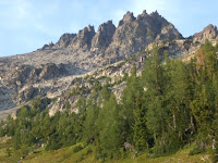 more popular trip of this area; to our surprise everyone was interested in our climb up Seven Fingered Jack as it was the harder of the two. As daylight was setting we needed to move on with the hope of getting to the main river trail before turn dark and the final 3.2 miles back to the car. About halfway along the path, we turned on our headlamps and made it back to the car at 10:30 p.m. The night was warm with stars all above and the moon illuminating the surrounding mountains. After covering 14 miles and an elevation gain of 6000 feet, it was yet again a remarkable day in the mountains. The Entiat Cirque is an area I have not been previously and look forward to coming back to climb the surrounding peaks that make up only part of the Washington 100.
 3.2 miles to Leroy Creek and then up the abandoned Leroy Creek trail eastwardly beside the creek, and in approximately two miles enters the upper Leroy Creek basin directly under Seven Fingered Jack and the east slopes of Mt Maude.
Seven Fingered Jack is the second highest of the three 9ers that make up the Entiat Cirque. The other two are Mt Maude and Mt Fernow, which at 9,249 feet is the third highest non-volcano in the Cascade Range. The name is descriptive of a rugged formation of steep crags once called "Entiat Needles".
We quickly set up camp at about 6,000' and made our way up the prominent gully northeast toward the Maude-col. We read this mountain was messy and notorious with loose rock and scree and recommended to keep party’s at a minimum due to the hazard of falling rocks.; therefore helmets were brought just in case. The key to scree, just as it is with soft powdery snow, is to ensure that each step is placed firmly but carefully in what I like to call "clean climbing" because it takes more energy to regain your balance than it does to climb itself.

Once up on the upper reach of the mountain, we navigated a series of small cliffs with slight exposure and then continued in a northeast heading to a large bench at 6,800'. It was apparent this was the point we needed to turn north and traverse the remaining section of the climb to a point underneath the summit finger. There was little snow on the mountain except for a large patch underneath the easternmost fingers. We passed a few other groups as when headed up and both warned that the key to the climb was to stay left even though the route naturally goes up into a false summit. There is no question that the route was loose and to my surprise there were very few cairns leading the way, but the more I thought it was very obvious that they could not survive in this environment due to the constant barrage of rocks falling from above. We continued to a good
 pace and enjoyed the view all around that include Glacier Peak in the distance surrounded by a marine layer of clouds. We wondering if the clouds would continue moving up and toward us, but at this point it did not matter with the summit directly above. and the weather from our vantage point was outstanding throughout the day.
We approached the final turn and turned back northeast toward the small saddle underneath the final summit finger, we ascended to the right on a knob which appeared to be the summit. We unclipped our packs and congratulated each other for a successful summit of Seven Fingers Jack. I pulled out a snack and quickly noticed a higher group of rocks across the gap from where we just came and was unfortunately the true summit. A studied the map and confirmed our position that to the east of
 the true summit and was more exposed than the actual route to the true summit. I scanned the best route from our current vantage point as it appeared that the only route was heading up the ridge required a class 5 climb. Knowing this was not the route per Becky's, I continued to look across the deep couloirs which separated us the opposite side but enough of guessing, I climbed across to take a closer look. As I expected, there was a narrow path along the rock which gave access to the backside of the summit and an easy walk to the final summit. We ascended the firm rock and within 10 minutes were actually on the true summit which deserved the premature congratulations. The summit including a flat area built up similar for a tent platform, but I believe it has been carved out for better protection from the deep cliff on the opposite side of our route. Initially our turnaround time was 7 p.m. on the summit and we
  made it at 5:30 p.m. and a bit less than three hours. We spent only a few minutes on the top and the idea came to us to go ahead and hike all the way back to the car to have a full day at home before work on Monday.
As with any mountain making it to the top is only halfway up and heading back in the loose rock required care to prevent a rock slide and/or twist of the ankle. We made our way down back without incident to the 6800' bench and from there, continued to down climb the small cliffs which we came. Soon enough we were back in the high open meadows and the basin. We spoke to a couple groups in the basin and discovered that Maude seemed to be the
 more popular trip of this area; to our surprise everyone was interested in our climb up Seven Fingered Jack as it was the harder of the two. As daylight was setting we needed to move on with the hope of getting to the main river trail before turn dark and the final 3.2 miles back to the car. About halfway along the path, we turned on our headlamps and made it back to the car at 10:30 p.m. The night was warm with stars all above and the moon illuminating the surrounding mountains. After covering 14 miles and an elevation gain of 6000 feet, it was yet again a remarkable day in the mountains. The Entiat Cirque is an area I have not been previously and look forward to coming back to climb the surrounding peaks that make up only part of the Washington 100.
Mt Shukan 9113 feet November 28th
This climb was mid-week decision with a promising weather forecast on Saturday, but that quickly changed as a winter front pushed in from the Canadian north. On Thursday night, we decided to go ahead and make a run at the summit even though we only had a day and half available for this North Cascades winter trip.
We left the car in the rain at 2500 feet and climbed the overgrown logging road to 3200 ft where the actual Shannon Ridge trail starts. The trail switched back up to the ridge at 4700 feet when we stopped to put on snowshoes due to the deep snow. We continued on the ridge for a
 mile or so until we started traversing up to the pass that provided access to the southern flank of Mt. Shuksan. In knee deep snow even with the use of snowshoes, we gained the col at 5400 feet.
Once we reached the col, the wind increased and the rain turned to sleet which found every crevice in our waterproof gear. From there, we needed to traverse a step incline under massive cliffs to gain the lower section of the Sulphide Glacier. As I stepped onto the snow, a small slab avalanche released down the face below and
 I instinctively dropped into the snow slamming by trekking poles into the first layer. Luckily I stuck to the face and we paused to decide if going forward was the right decision.
For the larger part of the traverse, the incline was step but ran out into small cirque 300 feet below which would offer plenty of excitement, but nothing fatal, however there were a few exposed sections that would require a quick self arrest to stay on the mountain. We proceeded slowly and once on the other side of the cliffs the westerly winds were blocked but now a northerly wind was driven down from the upper mountain into our soaked gear. We were 400 feet below the snout of the Sulphide Glacier when we decided to set camp on the snow field instead of continuing up into the fierce wind.
We found a large boulder that might offer some relief to the sleet and strong winds, so I pulled out my snow shovel and started digging a platform for the tent. With the slope and soft powder of the mountain, it was difficult to dig a level platform, but we did our best with the circumstances. We dove into the tent at 2pm and waited…
Our options were limited to either climb to the summit now or to wait until 1am and make the attempt. On a normal day reaching the summit would take 5 to 6 hours from here, but with the weather as it was and the soft snow conditions
 requiring snowshoes most of the way up, the summit bid would take much longer. Even if we were able to make it in 6 hours, nightfall would arrive at 5 pm far sooner than our need to be past the steepest part of the climb, the summit pyramid that gains 1000 feet in less than ¼ of a mile. We decided to hold out and see what the night would bring. In the dark and dreary tent, I knew the beauty of this climb is the sense of what it really takes to climb a mountain in any conditions when a high level of success is required to meet the demands of 360.
First of all it takes time and patience. Hunkered out in a tent for 17 hours straight with just your personal thoughts is just as demanding as the climb itself. Suggestion, always have a flask of bourbon. Second it takes tremendous planning. My mountaineering style has always been to travel alpine (lightweight) style to support the quick weekend summit trips of
 the Northwest Cascades. In most cases, they did not required the same level of planning, but brute force to gain the summit and as the level and commitment to the mountains increases, it will require deeper planning to counter the unknown factors including weather, difficultly, and time. Third, it takes preservation of your body and gear. I realize my brute force reserve is not as deep as it once was and I am developing habits to perform at the same level including the best use of my gear. What do you do when during the approach to the summit, the weather finds every crease in your waterproof gear and what was in plastic bags like your sleeping bag still gets wet due to the continual drip in your high performance mountaining tent? Always remember my friend that freezing snow is better than wet sleet! Therefore, you may have planned the right amount of time, but does your wet gear agree with that since it may require a week or longer to wait out the weather? Don't get me wrong because in the mountains, few things are comfortable, but it takes extreme care to survive in these conditions including a successful summit bid. Remember, “getting to the top is only only half the journey”.
At 1 am, the sleet continued to pummel the tent and our hopes were looking slimmer by the minute. As we waiting in our wet but warm sleeping bags, the conditions
 worsened and at 2am we knew we must postpone our climb of Mt Shuksan to another day. First, since time was not an option and we needed to be back home Saturday night waiting out another day was not feasible. Second, our planning was hampered by the weather even with the route firmly in my Garmin eTrex GPS. Third, we were soaked to the bone with no hopes of drying out. The trip was a beautiful learning experience.
In summary, I’ve been climbing many years with short weekend summit attempts, but this trip personally taught me what is required to maximize your chance of success with a project like 360. Every attempt is precious and it takes time, patience, planning, and knowing how to survive and succeed in the mountains in any conditions. Looking forward, insuring that every part of each trip is present will only insure of achieving this goal. No summit, but lot’s of knowledge of what it takes to be a true Mountaineer.
Rutth Mountain 7115 ft October 25th
We left the trailhead at 3100 feet and hiked four miles up Ruth Creek Valley to Hennegan Pass. The tree colors were beautiful as the fall season has arrived but the misty clouds covered the mountains high above. Once at Hennegan Pass, the fresh snow covered any evidence of previous tracks
 so we set the GPS and headed south off the trail up a relatively steep ridge. Once on top of the ridge, we blindly traversed the step face in knee-deep snow in white out conditions. We gained a small ridge and discovered a worn trail exposed in the surrounding ground brush.
We now knew we were on the right approach and continued on a moderate ridge toward the hidden mountain above. We came to a rocky outcropping on the edge of the Ruth Glacier and knew on a clear day, she would be in full view at this point, but our sweat told us the landscape was about to change. We stopped at a large group of rocks to scout our
 next direction and just as we thought, the sky cleared enough to expose the massive rock and crevasses on the glacier. We decided to rope up with crampons and that turned out to be a good idea. As we continued the clouds quickly lifted and the mountain was remarkable. The windblown ridge leading to the summit was covered with virgin snow and glisten brilliantly in the morning sun. As I led, I felt as if I was high on a primitive first ascent somewhere in another country. I was in heaven. As we crested the final slopes, there was one final push to the summit.
The summit views were breathtaking now that the clouds we climbed through where so far below. Our timing was perfect and the entire rise was in view and every peak over
 6000 feet was coming through the clouds. I felt as if I could reach out and touch Baker and Shuksan in the clear, crisp morning air. We spent over an hour on the summit enjoying our reward drinking hot tea. The climbing season is never over.
Mt Baker Direct Summit Climb 10,781' via Easton Glacier October 13th
This year has been all about Mount Baker. Less than an hour and half away and in sight from my backyard, Mt Baker offers a continuous way to train and maintain a high level of mountaineering fitness. The lone tent on the summit during my solo attempt a few weeks ago intrigued me enough to create the perfect weekend challenge, a direct climb and overnight camp on the summit.
I packed my gear for another solo attempt but decided due to the recent Cascades snowfall, a solo would be to close to the edge. I needed to leave before noon in order to climb and set camp on the summit before nightfall, which my GPS confirmed a 7:22 pm sunset. Unfortunately, my climbing partner was
 not able to leave until mid afternoon so it was decided to direct climb from the trailhead as I did earlier in the summer. We arrived at the trailhead at 2:30 am estimating we would reached the summit rim sometime before 9 am comparing to my 5 hour climb weeks earlier, but for some reason I did not think back to the 8 hours it took earlier in the year on the same Schreiber's Meadows/Easton Route.
As the horizon hinted the coming morning, we arrived at the "highest" high
 camp at 7000 feet. It was evident the snow was deep as we stepped onto the glacier and there were no signs that any other climbing parties were making a attempt this morning. As Mt Baker awoke in the morning light, we clearly saw the transformation that has taken place as the year moves into the twighlight months. The crevasses were larger, deeper, and covered with the recent snow fall.
Nearing 9:30 am, we approached 9000 feet and the sun was quickly softening the deep snow. As I crossed a narrow snow bridge between two deep crevasses, the snow was hinting it's dangerous conditions. Also, the south face of Mount Baker is a 500 feet high with a 4o° grade headwall directly above a Bergschrund making any slip a fast ride to the dark depths below. The snow pack loading
 confirmed my concern and I decided to "spin" as we can always climb another day. It's always a tough decision to turn around but this is the first time I can remember "spinning" on a perfect day due my climbing intuition. Moments after turning around, I heard a large crack and a huge volley of snow was released off the adjacent Black Buttes. Instincts and experience are important in the mountains, but following them is most even more critical.
As we trekked through Schreiber's Meadows with Mt Baker intensely white in view, we knew we could have summited with remarkable views on such a perfect day, but I sensed a different satisfaction from previous climbs. By listening to mountain, I felt satisfied that the right decision is always to trust your instincts.
Mt Baker Solo Climb 10,781' via Coleman Deming Glacier September 14th It was a beautiful weekend in the Pacific Northwest and I decided to climb Mount Rainier. According to Rainier’s climbing blog, the route was in perfect condition, however I could not rally a partner in time and to do it solo required an advanced permit that I did not have. Therefore, I turned my eyes to the north and Mount Baker once again.
 I left my house at 1 a.m. and arrived at the Heliotrope Ridge Trail around 3 am with a goal to reach the summit at 9 am. I climbed through lower trail deep in the night and neared the upper slopes of the Coleman Glacier as the eastern sky faintly glowed with the coming day. From that vantage, I saw in the distance an avalanche that rested only 20 yards from the route, recently fallen off the Black Buttes cliffs. As I continued my solo climb, my senses remained on high alert aware of other potential dangers. The crevasses were deep and frequent but
  easily traversed. I climbed to the 9000 feet saddle 4 minutes before my checkpoint time that I calculated as I left the trailhead. It was 6:56 a.m. and the sky with remarkable. From there, the narrow path leads up the rocky cliff band to a point where it meets the Deming Glacier. The remaining route to the summit rim is a steep, exposed climb that requires extreme care. I reached the crater rim exactly at 8 am for a five hour climb from the trailhead. The summit was mine alone with the exception of a lone tent on the broad summit of Mount Baker. I hiked over to the summit and into a remarkable view of the North Cascades. I was surprised that I had not passed any one on my way up being most climbers leave for the summit at 1 a.m. I shrugged off the solitude and counted my blessings to what I had.
As I started my climb down I decided to traverse the south face for better purchase of my crampons over the icy slopes on the Roman Wall. Once I arrived back on the rock band, I could see below a number of climbing teams working their way up the mountain. As I continued down, the climbers keep coming with most carrying their skis n hope the sun would soften the icy slopes. I arrive back at the trailhead just after noon
 Climbing solo requires additional concentration due to the mountain conditions, but I found that it also gives you another level of flexibility and self determination. Many of the climbers and skiers I chatted with on the way down noted the lone headlamp high on the mountain as they climbed out of the tents in the morning. This gave me a sense of pride I realized later that to others, it seems too much of a risk. I am currently reading Ed Viester's book "No Shortcuts to the Top" which is about Endeavor 8000 and what started ProjectEarth360 for me personally. I thought a lot of that book as I climbed this morning and as all mountaineers say, “If you are asked why you climb, then it cannot be explained”. I truly love the mountains and the lifestyle that allows me to experience them as I do. I am truly blessed.
Mt Dickerman 5723 ft August 30th
Back on Mt Dickerman, spent a foggy but dry day in the mountains with my wife. We left the trail around 9:30 a.m. and made our way up the switchbacks
 to the first plateau leading to the cliffs on the northwest side of the mountain. On the way we stop to reflect the cross that was laid to the climber who died back in 2006 on this route. We continued on with hints that the sky would clear giving us the perfect summit view during lunch. Flowers were colorful, the air was fresh, but a few blueberries we found on the final flat plateau in which this area is known. We pushed on to the final switchbacks to the summit were partial views did give us a nice lunch.
Gothic Peak 6213' August 23rd
Much needed to stretch our legs after the Moab trip and to experience the contrasts of the
 Desert Southwest compared to the lush Cascades. We climbed a topic based in and turned north toward Foggy Lake. From there it is fairly steep hike toward the summit including the final fourth class climb. From the top we could revisit Baker, Shuksan, Del Campo, Sloan, Glacier, Stuart, Mount Daniel, Rainier, Pilchuck and the Olympics. We decided we had enough time to climb the two norther in spires of Gothic Peak, and down climbed the north side. All was well until we encountered a 20 to 30 foot cliff that required a 5.7 down climbing. Without our ropes we decided it was best not to take the chance of any slip and falling on the rocks below. We did however puch it to a point that was very interesting that required careful navigation back up where we came from the summit.
 Mt Baker 10,781' via Coleman Deming Glacier July 26/27th
We climbed to Hogsback high camp in
 partly sunny conditions hoping the 30% chance of rain would stay in check, but we were not that fortunate. We made camp, ate dinner, and crawled into our tents as the rain began.
We woke a little after 1am and stepped onto the glacier at 2:30 am. The weather seemed promising from the start and we traversed the first hill to catch up to a party of 12 from Western Washington University. The one thing I treasure on the mountain is the headlamps of climbers in the darkness finding their way through the night. If you've never experienced this moment, you can only understand by experience.
The weather changed as morning arrived with light rain and grey skies. Close to a white out, we made our way up the mountain to the saddle at 9000ft without any danger except the distance crevasses. This time last year, it was a different story with a
 change of winter snowfall from 583ft in the 06/07. Mount Baker holds the world record for the most snow in one year with a reported 1,140 inches of snowfall for the 1998-99 season.
Once on the rocky ridge, we ascended to 9900ft and jumped onto the Deming Glacier that would take us the rest of the way to the summit. With little wind, the snow conditions were good, but still no visibility except for the grey blankness all around us. We continued the final steep push to the crater rim at a elevation of 10,571ft. From there, the wind increased and boot tracks lead to the east. I usually have my GPS which provides marks from previous summit bids that would have been helpful here, but there was no luck in finding the small knoll that holds the summit register on the football size field as most parties were in the same situation. Having been on the summit numerous times and with 3 climbers pm their first attempt, I took a pole and all felt, righteously so, the summit was reached. (I checked on
 Google Earth and it actually shows the summit crater at 10,785ft verses the register at 10,781ft. Snow pack in winter?)
We climbed down to 8500 ft on the Coleman Glacier near the Black Buttes as we spotted in the distance this little squirrel that zigged it's way toward us. Surprisingly he continued to me at the head of the rope and paused at 3 feet on his hind legs. As started to reached in my pocket looking for scraps from a Cliff bar, and this little guy decided that I was the meal. He jumped my leg, scurried up, and started attacking me. I brushed him off and he scampered back to where he came never to be seen again.
 The rest of my team couldn't stopped laughing as I thought about how particular that little squirrel was either far from home or mad we disturbed his territory.
We continued on in the fog and finally arrived at camp where the deep clouds made finding camp difficult. After a 20 minute search we found our camp, packed up in the pouring rain and made out way to the trail head.
Mt Baker 10,781' (Direct from Schreibers Meadows to Summit) July 19/20th
We left trail head at Schreibers Meadows elev 3300 ft at 8:30 pm for a direct ascent of the summit. The evening was beautiful and as we ascended the railroad grade, the sun fell behind the western horizon. As we climbed through the high camps of other parties, it was evident that most climbers were trying to sleep in anticipation of the coming mornings climb. We stopped near 7000 ft to "rope up" and trading our treking poles for crampons and ice axes.
The night was remarkable and I have never experienced such a peaceful night on any glacier. The snow was perfect, the air was cool, the moon was full, the wind was calm; what a beautiful night to experience the mountain. We climbed via the Easton Glacier with frequent stops to marvel our surroundings as the entire mountain glowed from the moons reflection and only one word can describe this night, HARMONY. I actually climbed most of the way in my long sleeve t-shirt!
As we approached the lower crater rim, we could see the Christmas lights of climber's headlamp far below making their way out of high camp. We crested the summit ridge and traversed 15 minutes to the true summit. The eastern sky
 offered a faint hint of the coming morning and we signed the register and dug in above a 1000 ft cliff to watch the Sunday morning sunrise. It was colder now with a slight westerly wind, but nothing a down jacket couldn't cure. After 45 minutes I must have fallen asleep (I was told I was snoring) when we were awaken by the second summit party of the day. We inquired the time because neither of us had a watch, and calculated our arrival on the summit sometime before 4 am.
The hidden landscape brighten as the sky filled with the light, but
 still no sun above the horizon. We decided that it was time to move on so we dusted off the snow and made our way down the mountain. Interesting was that most parties working their way up the mountain inquired of our midnight climb because while we were looking at them far below, they were looking at us far above. Many said we were lucky to be going down as they we going up and all I knew is this night climb is the reason why I climb. We arrived back at the car at 10 am and made a mad dash for a tall cup of dark northwest coffee.
Snow Camp on Heather Lake - June 20th - 22nd
Easy two-mile trail to the beautiful lake surrounded by the cliffs of Mount Pilchuck and stayed the weekend
 with my two chocolate Labrador retrievers. Usually in the Northern Cascades Ranges in June, the snow would be clear with only slight traces on the lake, however this winter seasons gave us more snow than usual. Halfway up the trail the deep snow covered the trail, the lake, and its surrounding area. only a few small spots of the lake were open and not frozen. Dug a snow cave for the dogs being being I had my mountaineering tent. A group of friends were climbing up Sunday only and I climbed down to greet them at the trailhead, hiked back up, took then back down, and came back up again. For the weekend, 4 trips and 12 miles.
Mt Rainier 14,410 ft (Direct from Paradise to Summit) May 24/25th
We left Paradise Lodge at 8pm in rainy
 conditions and lighting in the western horizon. As we continued through the night, we were met by another intense lightning storm toward the SE with a thunder delay of 21 seconds, but closing. After a hour huddle under a exposed rock, we continued our climb in the dark of the night both cold and wet. We arrived at Camp Muir near 1am and dug our way into the public shelter for a hot meal before continuing on the climb. We packed up a little after 2am with the sky was clear and promising.
As we continue to Ingram Flats, another climbing team approached us whom had one climber needed to
 return to base camp. The remaining climber, a Rainer (12x) and Denali veteran, clipped into our rope and continued onto Disappointment Cleaver (DC). With fatal exposures off the DC due to cliffs and crevasses below, fixed ropes were required most of the way to the top to 13,000 ft. At sunrise on the top of DC, the weather turned for the worst, the winds accelerated, and visibility went to zero. From that point on, our climb was in white out conditions route finding wands on the glacier, requiring individual kick steps because the our tracks were taken by the wind in the short 20 meters between us.
Nearing 9:30 am, we were only 400 feet below the crater rim (13,800 feet) with no wands in sight. After a intense 30 minute search, the weather overtook our bodies with frozen faces, fingers, and toes. Leaning in driving icy winds, white out conditions, and 13 hours of constant climbing, the decision was made to "spin".
 Always tough to do, but summiting any mountain is only half the climb.
As we started down, it was a short time before the next wand we not be found. We "scanned" the area as one climber kept a visual of one wand, but again nothing could be found. As we continued to look for the next 30 minutes, we realized we might be lost high on the mountain with our winter survival skills required. It was decided before digging a snow cave for the night to plot the DC coordinates (13,000 ft) in my GPS and follow the signal. As we started down at that moment, another party higher on Rainier came through the white out blizzard also looking for the route to safety. We rescanned the area together and found the next wand. To note, our GPS coordinates were pointing us in the right direction.
Getting down the mountain to Camp Muir was extremely difficult in the wet, soft snow including a moment of hallucination on the Cowlitz Glacier of a guy riding a bike with his dog. Once back to Muir, we took a hour to rest and continued on. In my 10 year experience of climbing Mt Rainier, I've not experience worst
 snow conditions to Paradise from Muir. It was deep, wet, slippery, awkward, painful, and broken. We were back at the truck at 5pm, a mere 21 hours of continued climbing.
Looking back, we climbed direct from the Paradise, dodging lightning storms, ankle turning snow conditions, sleeting horizontal winds, and zero visibility the entire way, but we made it a mere 400 feet below the summit. The success of any adventure is not always the prize, but the stories on the way. What I have written above is merely a summary of that story.
-----------------------
Mt Dickerman - May 17/18th
It has been a long winter and today is the first weekend of climbing weather. Even though the gate at
 Deer Creek is closed, we will find a way to spend the weekend on the mountain.
We arrive at Deer Creek on Saturday morning and snow shoe the 4 miles to the actual starting point of the Mt Dickerman Climb. We start the "hike" and quickly find difficultly in "hiking" in the broken trail of snow and trees. We continue up the switch backs until we reached a elevation of 4200 ft. At this point, the trail was lost and we continued west in the direction we knew.

We trampled through the snow and brush until we reached the area snow shoot know for killing hikers a few years ago. We put on our crampons and proceeded with caution across the avalanche area. Once we found the path, we continued the trail to the cliff wall on the NW side of the mountain at 4800 ft. From there, we hike NE to the summit at 5723 ft.
We pitched camp on the summit and enjoyed the night with a hot "Mountain House" meal, a few shots of Jack Daniels, and great conversation. We awoke to a perfect sunrise and treasure of God breakfast in the sun. We broke camp and route found our way back to the exact spot we found a fallen balloon the previous day
 without the aid of our tracks due the melting snow. From there, we thought we were home free, but we were wrong. We were forced to down climb the south face including a 30 ft cliff wall were my buddy straddled a fallen tree and "monkey" climbed his was down a point otherwise stick. Luckily, our instincts were correct and we found the original trail and yelled like scalping Indians. We continued to the trail head and finished with a 4 miles snowshoe trip to the truck. It's great to start the year with a summit camp in perfect weather and views of the previous years adventures.
Winter Hike to Lake 22 January 1st, 2008
Great start to the year on New Years Day with a simple snowshoe hike to Lake 22. Perfect weather but cold making my new Christmas gift of a Mountaineering Hardware Down Jacket even more the better. I was as snug as a bug in a rug sipping my hot tea in the deep winter snow.
----------------------
Mt Baker 10,781 ft
This summit attempt was the standard north route via the Coleman-Deming glacier, a.k.a Heliotrope Ridge route. As soon as we stepped from the car, the rain started and continued to fall lightly the entire way to high camp near the Coleman Glacier's icefall at 5600 feet. As night approached, the rain let up briefly and gave us hope for a clear summit attempt. At 2:00 am we awoke in the pouring rain, made breakfast, prepared our gear, roped up, and made our way up the the 35 deg slope.
 We continued climbing on the Coleman glacier until when we took our first break, under "Black Buttes" near 7200 feet. Even though the rain stopped, the visibility was near zero requiring GPS navigation in a heading of southeast toward the col. We encountered numerous climbing parties as we climbed and all advised of a impassable crevasse at 8800 feet; however we choose to check it out first hand. As we approached the upper section of Coleman Glacier, the mountain offered hints that the weather would break, exposing the massive rock face we were climbing toward. Nearing 8600 feet, we learned from another climbing group that there was a small snow bridge on the crevasse's far east side directly below the cliff wall that no party today ventured across.
The 2' wide snow bridge spanned the enormous crevasse visible on both sides, similar to walking on railroad tracks as a kid. If there was ever a place to belay the climber, this was it as we as a extra precaution set up fixed anchors. Once across, we took a short break as the snow began to fall then continued toward the col (saddle) between Mount Baker and Colfax Peak at 9000 feet.
 Once on the col, we climbed the rocky crest above Deming Glacier to the base of the Roman Wall, which is the last obstacle on the way to Mount Baker's 10,778-foot summit. The Roman Wall is nearly 1000 feet of 35-45 degree snow and ice that rolls over onto the summit ice cap of Mount Baker. It was at this point on the icy slope that the sleet turned dangerous and froze everything we touched. Now above the same cliff wall near the snow bridge, we knew the risk and the difficulty of stopping ourselves if required. It was this moment that we choose to "spin" to insure of our safety back to camp. We carefully turned the party around, down climbed to the col,
  belayed over the snow bridge, and traversed back to high camp all in a white out blizzard. We quickly broke camp, climbed back to the trailhead, and drove out to the main road, this the the view we took. I've seen the weather turn for the worse, and I've seen the weather turn for the better. Well, you can always climb another day.
-----------------------
Mt Whitehorse
48° 13' N; 121° 41' W 6880 feet
July 15th, 2007

Located southwest of the the Sauk River near the the town of Darrington. While not of particularly high in elevation for the North Cascades, it is noted for it's steep relief with the north face rising 6,000 feet in less than 2 miles.
I soloed this climb via the standard route is the Northwest Shoulder which I started in cloudy conditions on the difficult trail hike to
 Lone Tree Pass, then dropped nearly 600 ft in down climbing snow to the traverse toward the eastern climb that puts you on the glacier, and exposed scrambling to the top that makes this a strenuous climb. The summit view still proved hidden once near the top with on and off whiteout conditions. As I pulled back into the highway late in the afternoon, my view was definitely clear.
-----------------------
Vesper Peak
Vesper Peak in one of my favorite mountains in the Cascades. The entire trip is only 3.5 miles to the summit via Headlee Pass where the views toward the mountain feel much larger than 6214 ft.
We climbed
 through the deep snow, across a frozen lake, and directly up a small cliff wall of ice (we missed the normal route on the south side of the lake). Once on top, we traversed the remaining section and found the normal route to the summit rocks. Vesper holds a secret on the northwest slope with a 3000 feet direct drop into the Copper Lake valley. There are few mountains that hold so much potential as Vesper Peak to any mountaineer.
-----------------------
Mt Rainier 14,410 ft
We left Paradise on a sunny morning afternoon for Camp Muir. As we approached, the mountain could be touched with our fingertips, being so close in the sky. We continued
 on the Muir Snowfield that was desperately exposed of rock due to the lack of snow. I have been on the mountain many times and never seen the snow field as rocky as it was. Even the rangers as we climbed affirmed my thoughts of the bare rocky exposure.
We arrived at Camp Muir to a busy public shelter of many foreign climbers including Russian. and made camp on the common bunk area. The public shelter is a treasure of the world with the simplicity of the
 bunks, the camaraderie of the group, and the thrill of the coming adventure. We set up our stoves and prepared of dinner of Mountain House. After cleaning up, we prepared our gear and settled into our sleeping bags for the night.
We woke around 12:00 am and started the stove for coffee and oatmeal. It was clear that one of the climbers in our group was not in great shape with vomiting and dizziness. We slowly got ready for the summit bid including harness and snow protection devices. As we left the shelter around 2:00 am, the sky was clear and the stars were brilliant. We started from the high camp via the Cowlitz Glacier to the Cathedral Gap. From there, we arrived at the ridgeline and our partner could go no farther. After a "tempered" discussion, we climbed back down and as we hit the Cowliz Glacier, a charge came across me to "spin" the right way. We guided our climber to a safe zone and quickly unclipped and worked back up the Cowlitz Glacier to the Cathedral Gap. It was approx 3:30am.

Once on the crested ridgeline, we traversed to Ingram Flats, and descended under the Disappointment Clever (DC) due to extreme exposure of crevasses on the mountain. The end around was long, but around this time, we could up with the last party to leave Camp Muir well ahead of us. As we continued on, we encountered a 30 foot vertical climb know as "Hillary Step" for this climbing season and pushed toward the top of the DC nearing dawn. From there,
 we continued to pass large parties on out way to the summit and arrived to the crater around 9:30 am with the winds howling from the west toward us. We dropped into the rim and made the 20 minute hike to the true summit. The wind was fierce, but it was a life moment standing on the summit of the most challenging mountains in the lower United States. It is a point in time I will never forget.
----------------------
Del Campo Peak
6610 feet 47° 59' N; 121° 28' W
It was a beautiful morning as we left Barlow Pass for Gothic Basin. While exploring
 the area, we found a deep water pole nested inside 25 foot cliff wall. Even though the depth was over 40 feet deep in crystal clear water, the bottom was sparkling. We continued north to Foggy Lake and Del Camp Peak seemed miles away, but as we climber on, the base was reached in a less than 10 minutes. We scrambled on and the made our way to the top for a fantastic view of the surrounding valley including Glacier Peak, Monte Cristo, Vesper Peak, Mt Baker, and Rainier.
-----------------------
Mt Forgotten
6005 feet 48° 6' N; 121° 27' W
Another picture perfect summer day in '06 as we made our way on the Perry Creek Trail. We continued our way to the Mount Forgotten Meadows. The trail loses elevation to a rocky prominence and climbs back toward the ridge crest where it bend south toward the summit. From there, it a simple scramble to the summit and views of the entire North Cascade Range.
-----------------------
Mt Baker 10,781 ft
Mt Baker is the perfect mountain for the weekend mountaineer. From Schreibers Meadows, it only takes a few hours to get the high camp and high country. We arrived at High Camp via Railroad Grade around 5 pm and made camp. After dinner, we laid down for the night with intent of leaving for the summit at 1am but somehow, we slept until 6am. We got out up quickly, grabbed a bit to eat, and set off for the summit. The great thing about a team of two is the speed at which we climb. We went directly through the crevasse fields and caught up at 8600 ft with the climbing teams that leave in the middle of the night. We continued on, leaned over the thermo vents, and made the summit before noon.
------------------------------
Glacier Peak 10,541 ft
48°6′45.05″N, 121°6′49.70″W
A true adventure is a team of four with only one with any glacier experience. We left on Friday with the goal to return by Sunday night, a bold effort for the most remote mountain of the five major volcanoes in the Cascades in Washington. The first 5 miles to Old Mackinaw Shelter was flat and ran along the river. We camped there for the night, and in started bright and early on the switch backs that took us to Red Pass over looking a beautiful valley on the Pacific Crest Trail.
We continued onto the actual mountain and camped on the glacier for the night. We awoke at 1am, cooked breakfast, and left for the summit around 3am. It was evident as we started that our team would not break any speed records due to the glacier rope leaning curve. We continue through the morning and arrived at the high saddle sometime after sunrise. As we pressed onto the crest toward the false summit of Disappointment Peak, the air was fresh and the sun was brilliant.
We rounded the the false summit for the final push for the saddle, and after a lengthy delay, we carried on and made it to the summit nearing 2pm. The views were breathtaking and we enjoyed the our time on the summit.
The moment we descended off the summit, the sky closed in and the weather changed for the worst. As we arrived back at the lower saddle beneath the false summit, one climber was not feel well and another long rest was required. The descent proved just as slow but we continued on. As we approached an area from early in the day, a "shortcut" was decided that proved otherwise. We made it around it anyway with tempers flaring but continued down the final slope to camp. The sky closed in further and we found ourselves in a white out condition near dark, no sleeping bags, and camp no where is site. Lucky, at the final moment of light, we found our shelter, jumped into our bags and went to sleep. It was a long day and it was good to be at camp. We arose the next day, broke camp, and made our what to the trail head 18 miles away.
The descent was painful in my old boots and by the time I got back to the car, six layers of skin we gone from the back of my heal with blood everywhere. Climbing in 10% physical and 90% mental requiring ever conscience effort to make it the final 5 miles from the Old Mackinaw Shelter. I had no choose with a job interview in the morning which I desperately needed. We made it with yet another story to tell.
This is a list of what are generally accepted to be the 100 highest summits in Washington. It incorporates the 400- and 800-foot rules. Each mountain's rank, name, and elevation are listed, along with the region where the mountain is located and the USGS map showing the location of the peak. "Climbing & High Routes" by Fred Becky
---

Rank - Mountain - Elevation
1 - Mt. Rainier - 14,411 ft / 1 (June '08)2 - Mt. Adams - 12,276 ft / 1 (Sept '02)
3 - Little Tahoma - 11,138 ft /1
4 - Mt. Baker - 10,781 ft / 3I (Sept '00)5 - Glacier Peak - 10,520+ ft / 2I (June '06)
6 - Bonanza Peak - 9,511 ft / 2III
7 - Mt. Stuart - 9,415 ft / 1 Enchantments
8 - Mt. Fernow - 9,249 ft / 2II
9 - Goode Mountain - 9,200+ ft / 2III
10 - Mt. Shuksan - 9,131 ft / 3I (2010)11 - Mt. Buckner - 9,112 ft / 2III
12 - Seven Fingered Jack - 9,100 ft / 2II (Aug '09)
13 - Mt. Logan - 9,087 ft / 2III
14 - Jack Mountain - 9,066 ft / 3II
15 - Mt. Maude - 9,040+ ft / 2II
16 - Mt. Spickard - 8,979 ft (8,879 ft) / 3I
17 - Black Peak - 8,970 ft / 2III
18 - Mt. Redoubt - 8,969 ft / 3I
19 - Copper Peak - 8,964 ft / 2II
20 - North Gardner Mountain - 8,956 ft / 3III
21 - Dome Peak - 8,920+ ft /2III
22 - Gardner Mountain - 8,898 ft / 3III
23 - Boston Peak - 8,894 ft / 2III
24 - Silver Star Mountain - 8,876 ft / 3III
25 - Eldorado Peak - 8,868 ft / 2III
26 - Dragontail Peak - 8,840+ ft / 1 Enchantments27 - Forbidden Peak - 8,815 ft / 2III
28 - Mesahchie Peak - 8,795 ft / 2III
29 - Oval Peak - 8,795 ft / 3III
30 - Fortress Mountain - 8,760+ ft / 2II
31 - Mt. Lago - 8,745 ft / 3II
32 - Robinson Mountain - 8,726 ft / 3II
33 - Colchuck Peak - 8,705 ft / 1 Enchantments (June '09)34 - Star Peak - 8,690 ft / 3III
35 - Remmel Mountain - 8,685 ft / 3II
36 - Katsuk Peak - 8,680+ ft / 2III
36 - Sahale Mountain* - 8,680+ ft / 2III (July '09)38 - Cannon Mountain - 8,638 ft / 1 Enchantments
39 - Mt. Custer - 8,630 ft / 3I
40 - Ptarmigan Peak - 8,614 ft / 3II
41 - Sherpa Peak - 8,605 ft / 1 Enchantments
42 - Clark Mountain - 8,602 ft / 2II
43 - Cathedral Peak - 8,601 ft / 3II
44 - Kimtah Peak - 8,600+ ft / 2III
45 - Mt. Carru - 8,595 ft / 3II
46 - Monument Peak - 8,592 ft / 3II
47 - Cardinal Peak - 8,590 ft / 2II
48 - Osceola Peak - 8,587 ft / 3II
49 - Raven Ridge - 8,580 ft / 3III
50 - Buck Mountain - 8,528 ft / 2II
51 - Storm King - 8,520+ ft / 2III
51 - Enchantment Peak - 8,520 ft / 1 Enchantments
53 - Reynolds Peak - 8,512 ft /3III
54 - Martin Peak - 8,511 ft / 2III
55 - Primus Peak - 8,508 ft / 2III
56 - Dark Peak - 8,504 ft / 2III
56 - Mox Peaks - 8,504 ft / 3I
58 - Cashmere Mountain - 8,501 ft / 1 Enchantments
59 - Klawatti Peak - 8,485 ft / 2III
60 - Mt. Rahm - 8,480+ ft / 3I
60 - Horseshoe Peak - 8,480+ ft (8,440 ft) / 2III
62 - Big Craggy Peak - 8,470 ft / 3II
63 - Hoodoo Peak - 8,464 ft / 3III
63 - Lost Peak - 8,464 ft / 3II
65 - Chiwawa Mountain - 8,459 ft / 2II
66 - Argonaut Peak - 8,453 ft / 1 Enchantments
67 - Tower Mountain - 8,444 ft / 3III
68 - Mt. Bigelow - 8,440+ ft / 3III
68 - Dorado Needle - 8,440+ ft / 2III
68 - Sinister Peak - 8,440+ ft / 2III
68 - Little Annapurna - 8,440+ ft / 1 Enchantments
72 - Emerald Peak - 8,422 ft / 2II
73 - Dumbell Mountain - 8,421 ft / 2II
74 - Greenwood Mountain - 8,415 ft / 2II
75 - Mox Peaks - 8,407 ft / 3I
76 - Saska Peak - 8,404 ft / 2II
77 - Pinnacle Mountain - 8,400+ ft / 2II
77 - Azurite Peak - 8,400+ ft / 3III
77 - Luahna Peak - 8,400+ ft / 2II
80 - Blackcap Mountain - 8,397 ft / 3II
81 - Courtney Peak - 8,392 ft / 3III
81 - South Spectacle Butte - 8,392 ft / 2II
83 - Martin Peak - 8,375 ft / 2III
84 - Lake Mountain - 8,371 ft / 3II
85 - Golden Horn - 8,366 ft / 3III
86 - West Craggy - 8,366 ft / 3II
87 - Mt. St. Helens - 8,365 ft / 1 (Sept '02)
88 - McClellan Peak - 8,364 ft / 1 Enchantments
89 - Devore Peak - 8,360+ ft / 2III
90 - Amphitheater Mountain - 8,358 ft / 3II
91 - Snowfield Peak - 8,347 ft / 2III
92 - Austera Peak - 8,334 ft / 2III
93 - Windy Peak - 8,334 ft / 3II
94 - Cosho Peak - 8,332 ft / 2III
95 - Big Snagtooth - 8,330 ft (8350 ft) / 3III
96 - Mt. Formidable - 8,325 ft / 2III
97 - Abernathy Peak - 8,321 ft / 3III
98 - Switchback Peak - 8,321 ft / 3III
99 - Tupshin Peak - 8,320+ ft / 2III
100 - Flora Mountain - 8,320+ ft / 2III
Rating System
http://en.wikipedia.org/wiki/Grade_(climbing)
YDS (Yosemite Decimal System)Grade I: one to two hours of climbing. Grade II: less than half a day. Grade III: half a day climb. Grade IV: full day climb Grade V: two day climb. Grade VI: multi-day climb. Grade VII: a climb lasting a week or longer
---
Class 1: is walking with a low chance of injury and a fall unlikely to be fatal. Class 2: steeper scrambling with increased exposure and a greater chance of severe injury, but falls are not always fatal. Class 3: steeper scrambling with increased exposure and a greater chance of severe injury. Class 4: can involve short steep sections where the use of a rope is recommended, and un-roped falls could be fatal. Class 5: is considered true rock climbing, predominantly on vertical or near vertical rock, and requires skill and a rope to proceed safely. Un-roped falls would result in severe injury or death.